Getting to Know the Interactive U of A Public Map

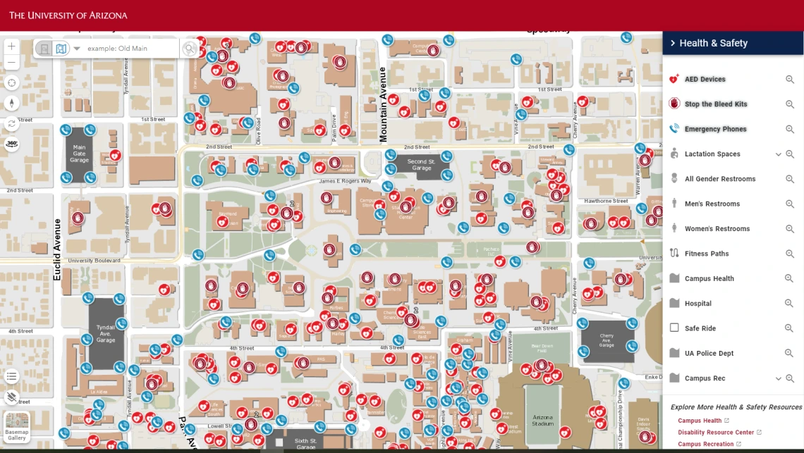
This screenshot of the U of A public map shows the location of health & safety resources including AEDs, Blue Light phones, and Stop the Bleed kits.
Finding a classroom at the University of Arizona can be a challenge sometimes, but do you know where to find an Automated External Defibrillator (AED), a Blue Light Emergency phone, or other essential safety resources on campus?
“It’s not enough to talk about safety resources. Knowing where safety resources are before an emergency happens can be life-saving,” says U of A Vice President and Chief Safety Officer Steve Patterson.
The interactive U of A Public Map is designed to help students, faculty, staff and visitors navigate campus, classrooms and parking, while also providing important health and safety information.
Created by the university’s Enterprise Geographic Information Systems (EGIS) team in collaboration with University Marketing and Communications, University Information Technology Web Services, and CALES Communications and Cyber Technologies, the map has been serving the university community for more than a decade.
“The map gets substantial use at the beginning of the semester, which is when it is in peak demand,” said EGIS Director Grant McCormick. “We have tens of thousands of users in the first few days of the semester which tells us this map is serving an important purpose.”
Health & safety resources
By selecting the Health & Safety section on the right side of the map, users can easily find locations of AED devices, Stop the Bleed kids, Blue Light Emergency phones, restrooms, Campus Health, the hospital, the University of Arizona Police Department, and more for main campus (Tucson), Phoenix Bioscience Core, and Sierra Vista campus.
EGIS has made the map user-friendly, ensuring that it’s accessible to everyone, whether they are students, visitors, or staff.
“I think it serves a unique purpose in that it’s intended to be the map for the entire campus community. It doesn’t require logging in and it is mobile responsive, so, for example, if someone is coming to campus only once and needs to find a place to park, they don’t have to download or install anything, they can just open the map in a web browser on their device,” said McCormick.
New features
Recent updates to the map include locations related to Academic Life, Campus Services and Student Life. Now, users can find counseling and crisis support resources, like the location of Counseling and Psych Services (CAPS), on the map.
“Locations for Stop the Bleed kits are new and lactation stations are being added in the Health and Safety category,” said McCormick.
McCormick says they are currently testing a new feature where, students, faculty and staff can use their NetID to sync the map to their preferred campus location, and students can see their class schedules to help find classrooms.
And, EGIS encourages feedback. A feedback form is available on the menu in the Public Map where users can leave suggestions.
“We have created the map category structure so that it can be easily adapted as new topics are desired for addition to the map. There are always some things in flux but this structure allows flexibility to grow the information we share,” McCormick said.
Access to building emergency plans
In 2023, building emergency plans, which include information about evacuation routes and shelter-in-place protocols, were integrated into the map. Individual plans can be accessed by clicking on each building and logging in with a university NetID. This feature enables users to preplan and familiarize themselves with emergency procedures prior to a crisis.
Future of the map
The EGIS team points out the map’s Health & Safety features are best used for emergency pre-planning and awareness, but McCormick envisions further enhancements to the map, such as real-time interaction capabilities that could facilitate emergency responses as situations occur.
“I think it’s a significant step forward for emergencies with emergency plans being listed. Looking ahead, there are ways we can enhance it further with more interactivity and continually updated information to facilitate informed responses in the moment of an emergency, such as events integration, pedestrian emergency routing, and indoor maps,” said McCormick.
“The potential for growth and innovation with this map is endless,” said Patterson. “I see this map as an essential resource for campus safety. Being prepared and informed prior to an emergency is crucial.
RESOURCES
VIDEO: How to use the University Public Map
LEARN MORE: Visit the University of Arizona Enterprise GIS website to learn more about how this and other interactive campus maps were created.
